
Drone Roof Inspection in Longview, TX
Drone Roof Inspection
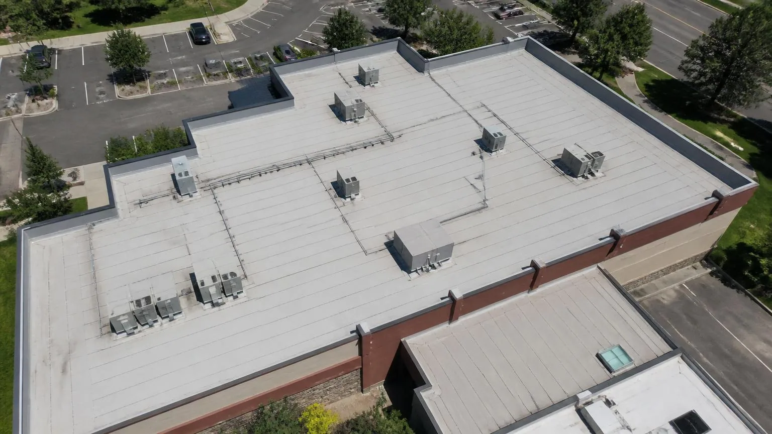
A drone can show the roof field quickly, but an image alone cannot confirm how firmly a membrane is attached or whether insulation is wet. We use aerial imagery to document visible conditions across large, steep, obstructed, or access-limited roofs, then identify which observations need a hands-on check. The flight can capture edge lines, rooftop equipment, drainage patterns, debris, and visible damage without putting a person on every section during the initial review.
Longview includes sprawling industrial properties near its highway network as well as close-set buildings in Downtown Longview. A facility near Longview Business Park may have wide roof areas and dense equipment clusters; downtown rooflines may include parapets and adjacent structures that limit sightlines. We plan imagery around building use, roof access, and safe airspace, then organize images by building and roof zone. The result is a visual record that supports a focused inspection rather than a substitute for field verification.
Plan imaging around the site
Before a flight, we confirm property boundaries, roof access restrictions, occupied areas, nearby roads, overhead lines, and the surfaces or details that need photographs. Longview sites near US 259, I-20, and East Texas Regional Airport may have different operating and airspace considerations, so the pilot checks applicable requirements and site conditions before launch. Wind, rain, heat, and visibility can affect image quality and whether a flight is safe. The facility contact should identify any sensitive operations or areas where people must remain clear.
The image plan follows a purpose: document hail or wind observations, map visible ponding, locate displaced equipment screens, record roof geometry, or prepare a baseline for later comparison. A hands-on roof inspection remains the right method for checking seams, probing soft areas, confirming attachment, and evaluating materials. We state in the deliverable which findings came from imagery and which were physically verified.
Review images for visible roof conditions
High-resolution imagery can reveal open-looking seams, displaced edge metal, debris accumulation, damaged rooftop screens, visible punctures, or areas where water appears to collect. We compare different roof zones and note features that deserve a closer look. A shadow, reflection, or surface color change can resemble a defect from the air, so the report does not treat every image anomaly as a confirmed failure. When detail is ambiguous, we mark it for field inspection rather than call it a repair.
Longview's July climate normals reflect sustained hot-season exposure, and a 2008 EF1 tornado track reached the city. After severe weather, owners can use photographs to establish a roof baseline. We record visible conditions and compare them with prior images when available. For a reported leak, imagery helps map the area but must be paired with interior information and a roof-level search for the entry path.
Know what an aerial view cannot verify
A drone does not test membrane adhesion, find moisture below an intact surface, or confirm what lies under ballast or equipment. It cannot determine whether a roof deck is structurally sound or whether a seam is watertight. A visual flight is also limited by obstructions, shadow, glare, weather, and line of sight. We identify coverage gaps and avoid drawing conclusions about hidden assembly conditions from a photograph alone.
Where imagery shows a suspected defect, we can schedule a safe hands-on inspection and targeted test. An infrared moisture survey may help identify areas for openings, but the readings and field tests must be interpreted together. If the roof needs a repair, a commercial roof repair scope describes the confirmed cause and correction. This sequence keeps aerial observations useful without overstating what they prove.
Build a visual baseline across buildings
For a multi-building property, repeatable photos can help compare condition over time. We use consistent flight paths and roof-zone labels when site constraints allow, then note changes in visible membrane, metal, drainage features, and rooftop equipment. A portfolio manager can use those images to decide which roofs should receive a closer physical inspection and to direct a crew to a particular area. The baseline is most useful when paired with roof plans, repair records, and known leak locations.
Longview's industrial and commercial corridors include buildings with distinct operations, so imagery should connect to actual property records rather than a single citywide label. A multi-site roof program can organize image dates, findings, and follow-up across assets. We preserve the property and date context and distinguish a new visible change from an unverified historical issue. That helps owners prioritize investigation without treating aerial color variations as proof of failure.
Coordinate occupants and flight safety
Flight safety depends on the site, weather, equipment, and people below. We set a launch and landing area, communicate the timing, keep the aircraft clear of active work and occupied paths, and stop if wind or visibility exceeds safe limits. The facility team can help identify access restrictions and schedule around deliveries, customer entrances, or production activity. If the roof is near air traffic or a restricted location, we verify whether the planned operation can proceed before scheduling.
Downtown Longview properties can have sidewalks and neighboring buildings close to the roof edge, while a business park may have wide yards and active loading areas. Each setting calls for a different safety boundary. The flight record notes the coverage, interruptions, and areas the camera could not capture. If conditions prevent useful imagery, we reschedule or select another inspection method instead of returning an incomplete set as a full roof review.
Deliver images with clear next steps
The final package can include dated images, a roof-zone map, visible observations, and a list of areas recommended for closer evaluation. Each item distinguishes an image finding from a confirmed defect. If the owner needs repair pricing, we first verify the detail and define the work boundary. A roof condition report can combine drone observations with physical inspection notes and maintenance priorities.
In Longview, share a roof plan, building list, access rules, and the reason for the flight. We will plan coverage around the property and explain what the imagery can answer. If there is active leakage or suspected structural damage, tell us before the flight so the inspection sequence addresses immediate risks and brings in the appropriate field checks.
A flight plan should identify roof sections, safe takeoff areas, nearby airspace constraints, and the views needed to answer the inspection question. Images can help document inaccessible edges or compare roof zones, but they do not reveal concealed layers. We label each image to a plan location and pair it with ground-level or hands-on checks where details require contact. If a roof feature is blocked by equipment or glare, state that limitation and schedule another inspection method for the unresolved area.
Commercial Roofing Questions
Can drone images confirm a commercial roof leak?
Images may reveal visible openings or drainage conditions, but they cannot prove where water entered or whether the assembly is wet below the surface. We use imagery to direct a hands-on search when needed.
Can you inspect every roof with a drone?
No. Weather, airspace, nearby activity, obstructions, and site rules can limit a flight. We check the location and conditions first and use another inspection approach when aerial coverage is not appropriate.
What does a drone roof inspection deliver?
A deliverable can include dated images, a roof-zone map, visible observations, and recommended areas for physical verification. It clearly separates image findings from confirmed conditions.
Can drone imagery replace a hands-on inspection?
No. Aerial imagery cannot test seams, attachment, deck condition, or hidden moisture. It is most useful as a way to document broad areas and focus the next field inspection.